")
")
")
Namibia Highlights with Zambezi and Vic Falls
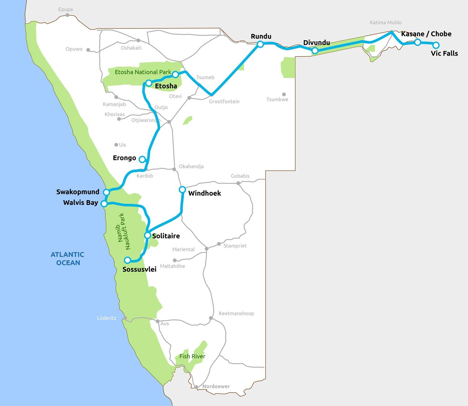
You could spend a lifetime exploring Namibia. Here we discovery a different part of Namibia. Showcasing the vast open and colorful landscapes of Namibia, the German influence in Swakopmund, incredible game viewing as well as the unique wilderness area of the Caprivi Region and a visit to the spectacular Victoria Falls!! Experience this area which is in stark contrast to the rest of Namibia with its great abundance of wildlife and unique vegetation combining the best of Namibia in just 15 DAY’s.
Highlights
- Windhoek
- Solitaire
- Sossusvlei and Deadvlei
- Walvis Bay and Swakopmund
- Erongo mountains
- Etosha National Park
- Okavango river
- Mahango National Park
- Zambezi (Caprivi strip)
- Chobe National Park
- Victoria Falls
DAY 1; Airport –Windhoek
On arrival you will be met by a representative of Odyssey Car & 4x4 Hire. Your tour will start by driving 42km to Windhoek the capital and largest city of the Republic of Namibia. You will receive a comprehensive 1-2 hours briefing of the vehicle, camping equipment & the route you will be driving. Following this you can buy provisions in Windhoek for the next 15 days self-drive adventure. Your first night spend will be overnighting in Windhoek in a Guesthouse.
If your flight are schedule to arrive after 15H00 no vehicle handover will take place only on day 2 but you would be transferred to your first nights’ accommodation. If flights are schedule to arrive before 10H00 am we can change first night in Windhoek to first night outside Windhoek to make day 2’s driving a bit less.
Notable landmarks to visit in Windhoek are: Parliament Gardens, Christ Church (lutheran church opened in 1910, built in the gothic revival style with Art Nouveau elements.), Tintenpalast (Ink Palace -within Parliament Gardens, the seat of both chambers of the Parliament of Namibia. Built between 1912 and 1913 and situated just north of Robert Mugabe Avenue), Alte Feste (built in 1890 and houses the National Museum), Reiterdenkmal (Equestrian Monument - a statue celebrating the victory of the German Empire over the Herero and Nama in the Herero and Namaqua War of 1904–1907), Supreme Court of Namibia Built between 1994 and 1996 it is Windhoek's only building erected post-independence in an African style of architecture.
Dinner at Sellenbosch Wine Bar Restaurant, Joes Beerhouse, Sardinia Blue Olive or Leo’s at the Castel would be a wonderful start to an African experience meal.

DAY 2; Windhoek – Solitaire/Sesriem/Sossosvlei
Today’s journey leads you to the southern parts of Namibia via the Tropic of Capricon to the Namib Naukluft Park the Khomas Highlands and the breath-taking view of the Spreetshoogte Pass.
Spreetshoogte Pass (Afrikaans: Spreetshoogtepas, literally English: Spreeth's Peak Pass) is a mountain pass in central Namibia, connecting the Namib Desert with the Khomas Highland by traversing the Great Escarpment, a geological feature of much of the southern part of the African continent. With gradients between 1:4.5 and 1:6 it is the steepest pass in Namibia, as well as the one straddling the biggest elevation difference, descending almost 1,000 metres (3,300 ft) within 4 kilometres (2.5 mi) of road. The top of the pass features a resting place from which there is a spectacular view into the adjacent Namib. The pass was erected during World War II by farmer Nicolaas Spreeth, after whom it is named.
You will then arrive at a small town called Solitaire the area was named Solitaire by Elsie Sophia van Coller (wife of Willem Christoffel van Coller). The name was chosen because of two meanings. Solitaire can mean a single set diamond and Solitaire can also mean solitude or loneliness. Combined these two meanings create the definition of being unique or one-of-a-kind and a precious but solitary place Solitaire is situated at the junction of main roads C14 (Walvis Bay - Bethanie), and C19 (Sesriem - Sossusvlei), both major tourist routes through the Namib-Naukluft National Park. At Solitaire you will find a petrol station, public restrooms, restaurant and bakery, the worlds famous apfel strudel, the settlement also contains a tire repair workshop and a motel, continue to your explicit lodge. Already in the afternoon you will have the opportunity to join in on the first activities the lodge has to offer or just relax at the lodge swimming pool or visit the Sesriem canyon.
Overnight in the Naukluft Park surrounding
DAY 3; Sesriem/Sossosvlei
Today will be a leisure day to enjoy the fantastic sight of the Sossusvlei Dunes, The dead vlei and if you did not visit the Sesriem Canyon the previous day then that can also be part of today’s schedule.
The Sesriem Canyon derives its name from the fact that early Afrikaner trekkers had to use six ('ses') leather thongs ('riem') so that their buckets could reach the water far below. Because it is so deep and sheltered, it often holds water well into the dry season.
The sand dunes of Sossusvlei in the Namib Desert are thought to be the highest dunes in the world. The best time to view Sossusvlei is close to sunrise and sunset, when colours and shades change constantly, offering a photographer’s dream. The midday heat is intense and best spent in the shade. 'Vlei' is the Afrikaans word for a shallow depression or pan, surrounded by spectacular red dunes, sometimes fills with water. The pan only has water on rare occasions, during exceptional rainy seasons, when the Tsauchab River flows into this pan. The Sossusvlei is mostly a dry vlei except in good rainy season. The sand-dunes at Sossusvlei are some 60km from the Sesriem gate (the entrance to the park) and the drive takes about an hour. The area also hosts various vleis, such as the Naravlei, so called because of the countless cucumber-like melons (a vital source of nourishment for many desert creatures, including man) growing around the edge of the pan. Dead Vlei boasts dead camelthorn trees, some being over 800 years old. Out of view from the 2x4 car park, tucked behind a dune, is Hiddenvlei.
Again, Overnight in the Namib Naukluft Park surroundings.
DAY 4; Sossosvlei – Swakopmund
Today you will depart through the rough Namib Desert till you arrive in the coastal town of Walvis Bay follow Swakopmund.
The Namib Desert, the world's oldest desert (43 million years), covers just under 50 000km² and incorporates the Namib Naukluft Park, a section of the diamond area to the south and the Skeleton Coast to the north, which was recently proclaimed as the Dorop Park. It includes the Swakop River and Kuiseb River Canyons, which are dry rivers, except in exceptional good rainy seasons.
Overnight in one of Swakopmunds fabulous Guesthouse.
DAY 5; Swakopmund / Walvis Bay
Today is yet another leisure day to participate in some activities. (Please book activities with us in advance).
Swakopmund (German for "Mouth of the Swakop River") is the ideal holiday destination of Namibia which lies on the west coast only 350km from Windhoek. Swakopmund was founded in 1892 as the main harbour for German South-West Africa, and a sizable part of its population is still German-speaking today. Boats were offloaded at Swakopmund’s landmark, the jetty. However, the natural potential of Swakopmund as a holiday resort was recognized, and this potential has subsequently been developed. Today tourism-related services form an important part of the town's economy. This little town is rich in beautiful German colonial architecture/buildings, e.g. the beautiful old train station which was converted into a hotel, the prison, the Woerman House which used to be the head office of the Woermann Line (colonial shipping line) and now houses the public library and shops, the Light House, the Jetty which now houses a restaurant, just to mention a few. Swakopmund has an excellent museum on the history of Namibia / Southwest Africa. Swakopmund has a lot to offer which include attractions like the National Marine Aquarium, the Crystal Gallery, the Martin Luther Steam locomotive and “things to do” like fishing, dolphin cruise, snake park, skydiving and quad biking, dune riding, ballooning, camel riding and excellent shopping possibilities.
Again, Overnight in one of Swakopmunds fabulous Guesthouse. Restaurants to try out in Swakopmind are the Jetty 1905, Swakopmund Brauhaus, The Tug, Kucki’s Pub, Tiger reef, Ocean Cellar, Old Stemer Restaurant & The Wreck Restaurant.
Day 6: Swakopmund – Erongo
After a good breakfast and before proceed with today’s journey, you can spend the morning walking in town of Swakopmund buying souvenirs, to carry Namibia back home or simply spend the morning with yet another activity. Today you will drive inland to the Erongo Mountains, via Usakos to your next destination. En-route you have the possibility to also visit a SAN Living Museum as the Erongo is home to thousands of rock paintings mostly done by San People.
The stunning Erongo Mountains are located in Damaraland, west of the town of Omaruru, and represent a 130-million-year-old volcanic complex of about 30km in diameter. The variety of rock and landscape formations in the Erongo mountains are every nature lovers, photographers and artists dream, with its spectacular, magical and dramatic light changes and contrasting light, transforming the mountain backdrop, granite flats and gigantic boulders into magical colours, especially early evenings and during sunset, the mountain range into magical colours. The mountain range also offers plentiful game, wildlife and birds. Precious stones are mined in the Erongo, especially aquamarine. The famous Phillips Cave is also situated here, known for its rock and cave paintings, which are protected heritage sights. The highest elevation surveyed is “Hohenstein” in the southwest of the mountain with 2 319m height, the Erongo Mountains in 2 216m height, and the highest human settlement in Namibia is situated here at 1 792m height.
Overnight in the Erongo Mountains.
Day 7: Erongo – Etosha
If you wish to, you can join a guided walking trail in the early morning hours exploring more of the Erongo Mountains. Afterwards you drive via Omaruru and Outjo to the south of the Anderson Gate.
Omaruru, a picturesque town, is situated in the centre of Namibia. This town is rich in history. It is also home to many artist and offers a yearly artist festival in August/September. The Omaruru river runs through the town, bordered by huge, ancient trees which add to the picture and character of the town. The name Omaruru is derived from the native word “Omaere” which is a traditional milk product. In 1871, Anders Ohlsson and Axel Eriksson established a brewery at Omaruru. Eriksson had also established a trading post, which flourished. Eriksson's business was based upon long-distance trading between southern Angola and Cape Colony. The town grew around a mission built in 1872 by Gottlieb Viehe, now a museum, and was attacked in 1904 during the Herero and Namaqua war. Captain Franke's Tower was later erected to commemorate the relief by Hauptmann Franke's troops of the local garrison that was beleaguered by Hereo tribesmen who had risen against the German colonial presence.
Overnight in the Etosha surrounding
Day 8 & 9: Etosha
You have two (2) full day, which you can use to explore the abundant wildlife in the Etosha Park, Namibia has to offer. This all in the comfort of your own vehicle or simply booking an activity with the lodge (Please book activities with us in advance).
The park is home to hundreds of species of mammals, birds and reptiles, including several threatened and endangered species such as the black rhinoceros.
ETOSHA NATIONAL PARK is the gateway to Northern Namibia and Ovamboland. It is Namibia’s prime wildlife location and home to a large variety of mammals and birds. Etosha means the ‘great white area ‘this refers to large dried pan in the middle of the Etosha Park. What makes this park unique is the floodlit waterholes at all the main camps. Visit Etosha National Park in Namibia this season and share in Namibia’s wildlife. Etosha Park is any photographers dream. Plan your visit to Namibia and experience the great white area of Etosha. The park was proclaimed a game reserve on March 22, 1907 in Ordinance 88 by the Governor of German South West Africa, Dr. Friedrich von Lindequist.
Overnight in Etosha Park
DAY 10; Etosha - Rundu
Today you have to set farewell to the Etosha Park, its animals and beauty as you will head up to the north boarder of Namibia via Tsumeb and Grootfontein the "gateway to the north".
The name Tsumeb is generally pronounced "TSOO-meb". The name is not a derivative of German, Afrikaans, or English. It has been suggested that it comes from Nama and means either "Place of the moss" or "Place of the frog". Perhaps this old name had something to do with the huge natural hill of green, oxidized copper ore that existed there before it was mined out. The town was founded in 1905 by the German colonial power and celebrated its 100th year of existence in 2005. The town is the site of a deep mine (the lower workings now closed), that in its heyday was known simply as "The Tsumeb Mine" but has since been renamed the Ongopolo Mine. Close to Tsumeb you will also find the larges and smallest of only two permanent natural lakes in Namibia. Lake Guinas (larges) and Otjikoto Lake (smallest) It a sinkhole lake, created by a collapsing karst cave. Otjikoto Lake was declared a national monument in 1972 and are known for the dumping ground for German Schutztruppe during World War I; in June 1915 German troops dumped war materials in the lake before surrendering to stop the South African and British troops from using them. Most of the larger pieces have been recovered and are displayed in Tsumeb Museum.
The Caprivi Region has a quite unique historical story to tell. Unlike the other regions in Namibia, the Caprivi has a completely different past. Till the end of the 19th century, the Caprivi has been known as “Intenga” and has been under the rule of the Lozi kings, but later forming part of the British “Bechuanaland” Protectorate (known as Botswana today).
Overnight on the bank of the Kavango River.
Day 11 & 12: Rundu - Divundu
Today’s journey will lead you along the Trans-Caprivi-Highway (A big matter which one has to be very aware of is the fact that there are no fences! So keep your eyes open for roaming wildlife!) to the Bwabwata National Park. You might want to visit the Popa Falls on your way. This is known as the Caprivi Strip.
Some 200 kilometres east of Rundu lies one of the scenic highlights of Namibia in the western part of the Caprivi Strip. Known as the Popa Falls where one can expect are rapids rather than waterfalls situated in an area of outstanding natural beauty. Here, the Okavango River breaks through a four-metre high rocky intrusion in its riverbed and tumbles down a series of rocky plateaus before the river enters Botswana and the Okavango Delta. This is an ideal base to explore the Mahango Game Park.
The entire Western Caprivi today is a game reserve known as the Bwabwata National Park. In the year 2002, the Western Caprivi Game Park and the former Mahango Game Park were joined to the new Bwabwata National Park. The park stretches from the rivers Kwando and Okavango, covering a stretch of land more than 5000 square km. Over 8000 elephants, as well as many antelope species, hyenas, buffalo, hippos, lions and leopards, inhabit this area.
Topography of the park is in the elevation range of 500 1,000m. The Okavango Swamps starts from this park area and is known as the panhandle region. The Okavango River flows into Botswana forming the Okavango Delta in that country. The Mahango Park is subject to two climatic conditions-the dry season lasting from April to November and the rainy season from mid-Novemberto April. The annual rainfall incidence varies between 550 and 600 mm and 80% of it occurs during the rainy season. The monthly average maximum temperature is reported as 30°C.The vegetation consists of 38% shrubland and 62 % grass land. Riparian forests are an important form of dense vegetation against the dry woodlands in the higher reaches of the river valley and reed beds, swamps, and open flooded grasslands of the flood plains. In view of this varying vegetational pattern, the park is rich in flora; with a reported 869 species from 88 families. The important riparian woodland species are Garcinia, Sclerocarya, Diospyros, Acacia and Grewia. The species reported from the desert areas are Pterocarpus, Ricinodendron, Ziziphus, Baikiaea and shrubs of Baphia. The flood plains have Phoenix and baobab Adansonia; the baobab trees in the park are very large. One of the more commonly found trees in the park is the Baobab. It has very rich diversity of mammal species; 99 species are reported, including elephants, lions, leopards, cheetahs, and hippopotami. Some of the key species which are under the threatened list are Lycaon pictus (EN), Loxodonta africana (EN), Kobus leche, and Lutra maculicollis (VU) found mostly in aquatic environment; Loxodonta africana and Kobus leche also migrate to neighboring countries. There are 71 aqua faunal species and five species of amphibians such as Phrynomantis affinis
Overnight in the Bwabwata Park
Day 13: Divundu – Kasane / Chobe
You should depart rather early today whilst driving via Kongola to Katima Mulilo, passing through the Caprivi Game Park which is a generally flat landscape except for some dunes covered with vegetation. Then you continue via the Ngoma Bridge boarder post to Botswana and drive to Kasane.
Ngoma is a settlement in the Caprivi Region of Namibia. It is one of the border posts between Namibia and Botswana, traffic crosses the border at Ngoma bridge over Chobe River. Ngoma Border Post is open from 07:00 to 18:00 (GMT+2), be prepared for long waiting times at the border.
Kasane is a town in Botswana, close to Africa's 'Four Corners', where four countries almost meet: Botswana, Namibia, Zambia and Zimbabwe. It is at the far north-eastern corner of Botswana where it serves as the administrative center of the Chobe District
Overnight close to the Chobe Park
Day 14: Kasane / Chobe / Victoria Falls
Today you can enjoy exploring the unique Chobe National Park or visit the spectacular Victoria Falls on a day trip.
Chobe National Park, in northern Botswana, has one of the largest concentrations of game in Africa. By size, it is the third largest park of the country, after the Central Kalahari Game Reserve and the Gemsbok National Park, and is the most diverse. It is also the country's first national park. The idea of a national park to protect the varied wildlife found here as well as promote tourism first appeared in 1931. The following year, 24,000 km² around Chobe district were officially declared non-hunting area; this area was expanded to 31,600 km² two years later. The park is widely known for its spectacular elephant population: It contains an estimated 50 000 elephants, perhaps the highest elephant concentration of Africa, and part of the largest continuous surviving elephant population.
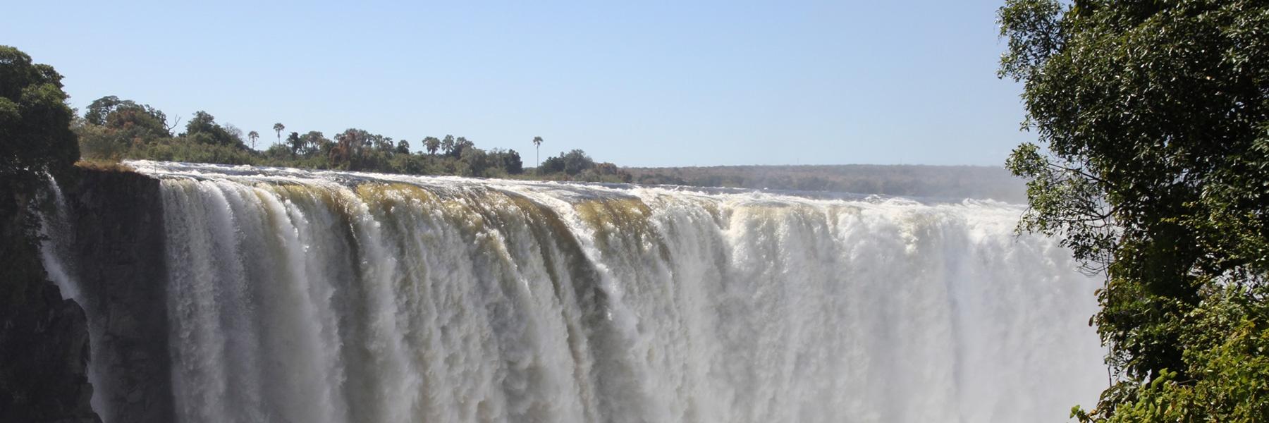
Victoria Falls, or Mosi-oa-Tunya (Tokaleya Tonga: the Smoke that Thunders), is a waterfall in southern Africa on the Zambezi River at the border of Zambia and Zimbabwe. David Livingstone, the Scottish missionary and explorer, is believed to have been the first European to view Victoria Falls on 16 November 1855 from what is now known as Livingstone Island, one of two land masses in the middle of the river, immediately upstream from the falls on the Zambian side. Livingstone named his discovery in honour of Queen Victoria, but the indigenous name, Mosi-oa-Tunya—"the smoke that thunders"—continues in common usage as well. While it is neither the highest nor the widest waterfall in the world, it is classified as the largest, based on its width of 1,708 metres (5,604 ft) and height of 108 metres (354 ft), resulting in the world's largest sheet of falling water.
Overnight close to the Chobe Park
DAY 15: Kasane Airport
Today are the end of your 15 day self-drive tour, so take a moment and enjoy the last African beauty before you have to head to Kasane airport and back home. A representative of Odyssey Car & 4x4 Hire would meet you at the airport of Kasane to collect the vehicle from you.
*** Hope to see you again soon ***
